- This event has passed.
AGU practice talks
4 AGU practice talks:
Hasbi Ash Shiddiqi | Implications of 3D teleseismic ray-tracing on focal mechanism determination
Helene Meling Stemland1,3, Tor Arne Johansen1,2,3 , Bent Ole Ruud1,3
1 University of Bergen, Department of Earth Science, PO Box 7803, 5020 Bergen, Norway.
2 The University Center in Svalbard (UNIS), PO Box 156, 9171 Longyearbyen, Norway.
3 ARCEx, UiT The Arctic University of Norway, PO Box 6050 Langnes, 9037 Tromsø, Norway.
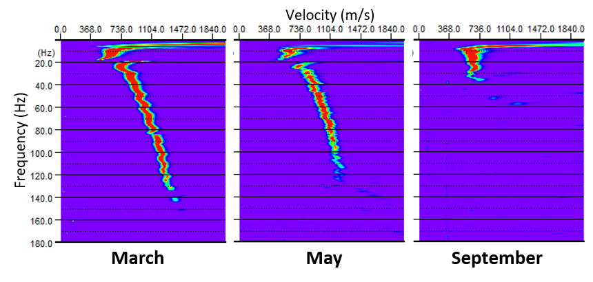
Arctic surface temperatures are increasing more rapidly than the world average due to feedback mechanisms, and an implication of this is thawing of currently frozen ground. Saline permafrost is particularly prone to following geomorphic consequences because saline pore-water gradually changes phase at subzero temperatures, hence even minor subzero temperature variations can lead to significant changes in the degree of freezing in such areas. To detect and monitor permafrost degradation, non-intrusive methods are desirable due to efficiency and environmental constraints. The effective elastic properties of the subsurface depend partly on the degree of freezing of pore-water. Since seismic surface waves are sensitive to changes in shear-wave velocity in particular, thawing of even very thin layers is reflected by changes in surface wave characteristics.
We have acquired seismic data in Adventdalen on Svalbard in the Norwegian Arctic during several field seasons using a variety of seismic sources, and we here investigate how the data vary with time and source type. Vertical geophones record surface waves of Rayleigh type. Data acquired with explosives show the strongest surface waves, but are dominated by an air wave. Thawing in the uppermost sediments usually affects high frequencies, but we here observe variation with time even at frequencies <50 Hz, likely related to higher modes of Rayleigh waves. We observe an inversely dispersive trend in frequency-velocity spectra of seismic records from winter, indicating dominant higher modes. This is typical for low-velocity sediments embedded in higher velocity sediments, and Rayleigh wave dispersion curves extracted from synthetic seismograms made for such a geometry provide a good match with observations. Previous studies have suggested that Adventdalen consists of eolian low-salinity sediments overlying raised marine high-salinity sediments. Thus, the upper sediments are more frozen (i.e. higher velocity) than those below during winter. Such an inverse velocity gradient makes traditional refraction seismic methods fail, and our results indicate that seismic surface wave methods are a viable option for monitoring thawing of frozen sediments. However, inversion of surface wave data with higher modes is not straightforward and requires further attention.
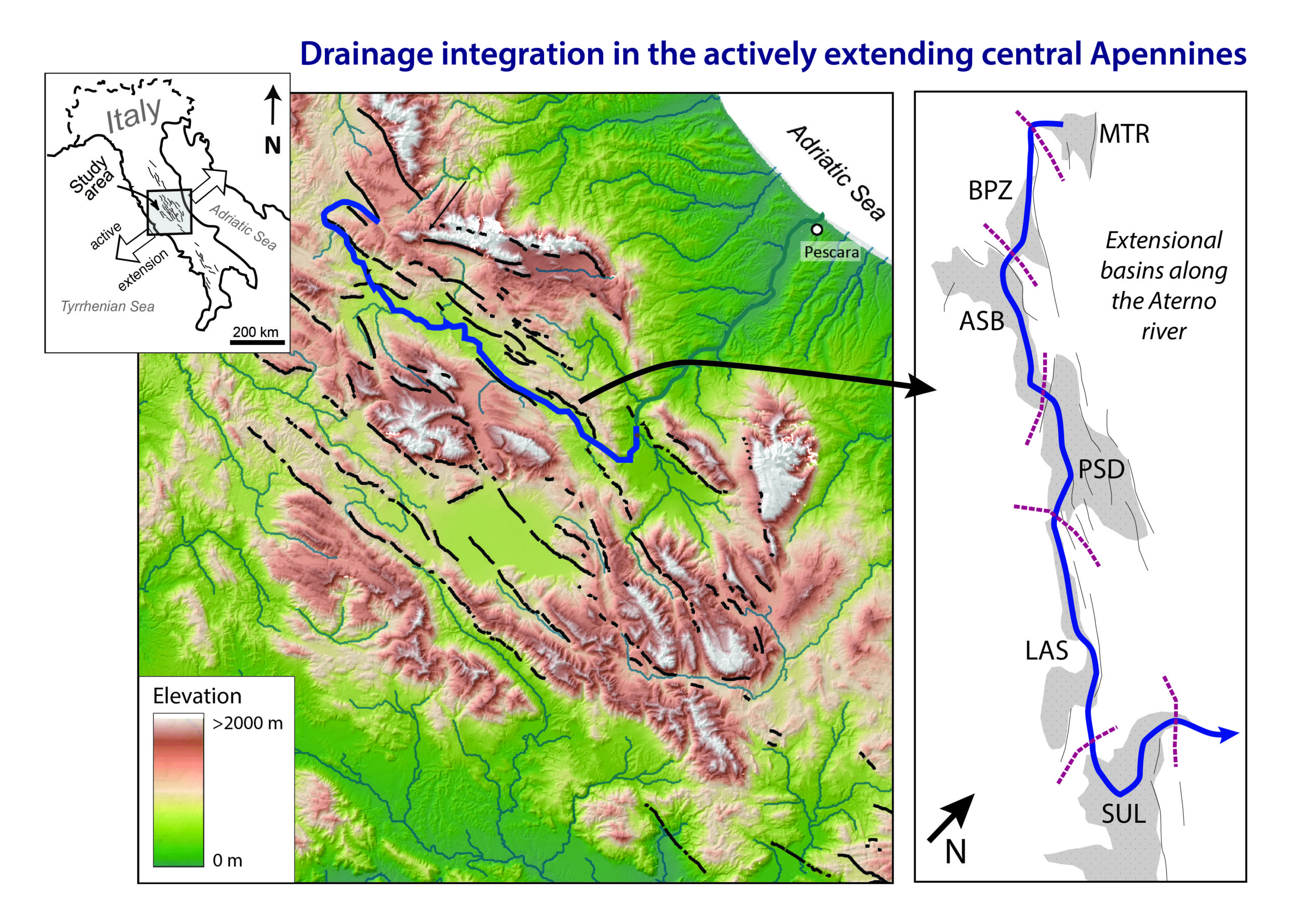
Anneleen H. Geurts, Alexander C. Whittaker, Rob L. Gawthorpe, and Patience A. Cowie
Drainage integration is an important phenomenon in the evolution of continental rifts. While fault-bounded basins are often internally drained in the early stages of extension, they tend to become progressively integrated with one another over time which has implications for both basin stratigraphy and landscape evolution. However, the drivers of drainage integration remain poorly understood. Here we use the actively extending central Italian Apennines to investigate the contribution of the river network itself to long-term (~3 Myr) drainage integration. We integrate detailed stratigraphic and geomorphic datasets for one of the largest river systems in the area (the Aterno river system) with results from regional-scale numerical modelling work. Our data compilation shows a disordered spatio-temporal pattern of drainage integration that we interpret to mainly result from the infilling and overspilling of fault-bounded basins and not from headward erosion from externally-draining catchments. Rates of sedimentation and basin subsidence in the central Apennines were almost matched during the initial phases of faulting, and only a small climate- or tectonic-induced increase in sediment supply was sufficient to tip the balance towards overfilled conditions. Slip acceleration associated with fault interaction in this region can explain why we observe in some stratigraphic records the re-establishment of underfilled conditions. Drainage integration abruptly modifies sediment dispersal patterns, as well as the magnitude and characteristics of sediment fluxes. Moreover, it induces successive waves of fluvial erosion associated with individual integration events. The rates at which these erosional waves propagate upstream suggest that the effects of drainage network evolution can persist in landscapes and sediment routing systems for millions of years following complete drainage integration. We conclude that drainage integration is just as important as tectonics and climate in controlling transient landscape evolution and basin stratigraphy in continental rifts and we recommend it to be considered explicitly as a driver of landscape evolution and sediment routing in areas of active extension, rather than simply as a product of external forcing.
Katharina Newrkla1, Hasbi Ash Shiddiqi1, Annie Elisabeth Jerkins2, Henk Keers1 and Lars Ottemöller1, (1)University of Bergen, Bergen, Norway, (2)NORSAR, Kjeller, Norway
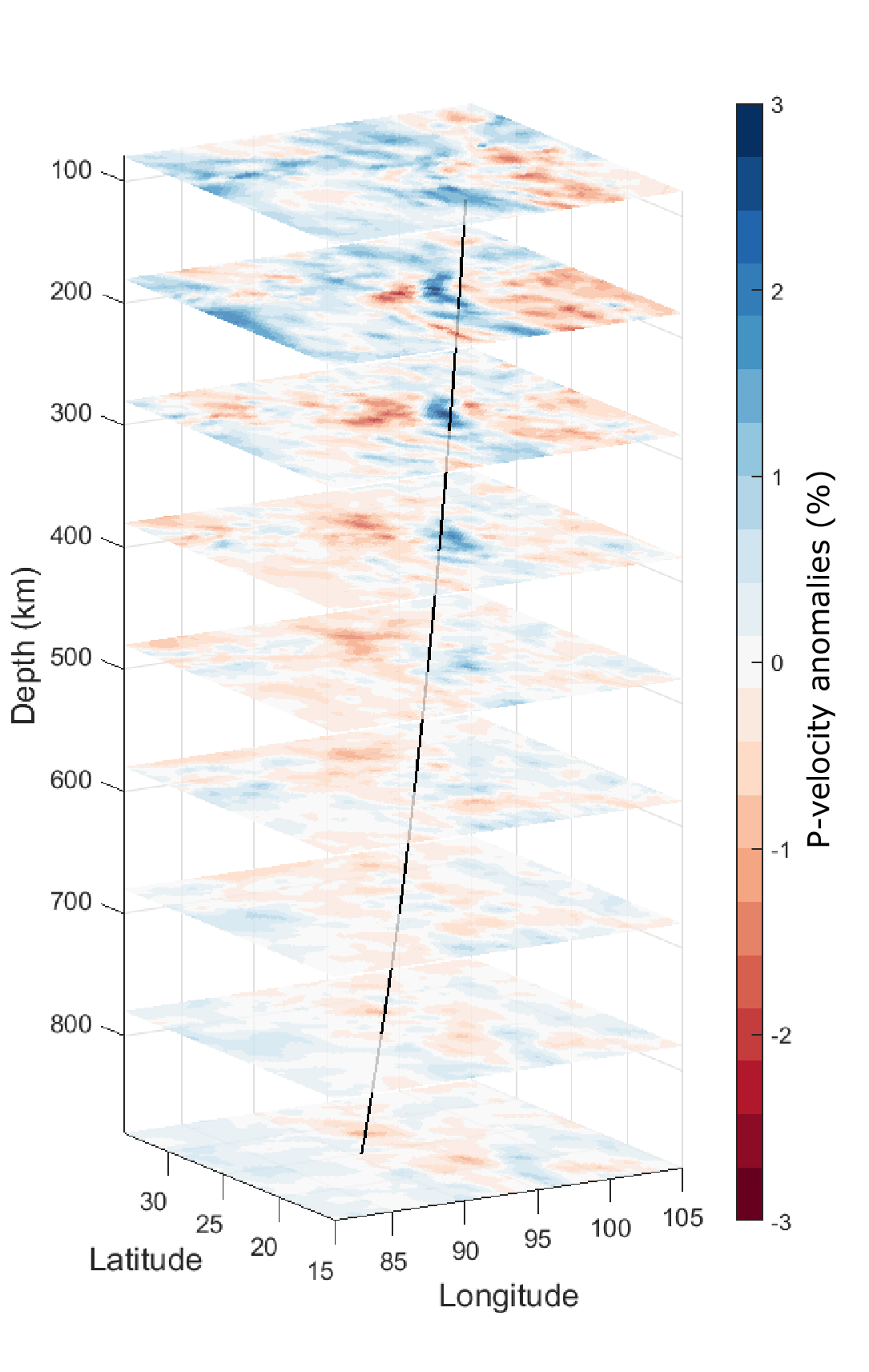
This study investigates the apparent mismatch of first motion polarities at teleseismic distances in focal mechanism determination. We hypothesize that especially deviations from the 1D model in the larger source region are responsible for this mismatch. In this study, four seismic ray tracing algorithms are implemented in a spherical coordinate system to compute ray paths and travel times. We compare the results of the Euler, symplectic Euler, midpoint, and 4th-order Runge-Kutta numerical methods in order to determine their accuracy. The Runge-Kutta method, which produces the most accurate result, is used to compute the take-off angles from the hypocenter of the 24 August 2016 Chauk Mw 6.8 earthquake (depth 90 km) in Central Myanmar to four seismic stations in Europe using a 3D regional velocity model of the upper mantle below Asia. In a previous study, the observed waveform polarities from these stations did not match the focal mechanism solution of the 2016 Chauk earthquake derived using a 1D velocity model. The differences in the azimuthal angles calculated in the 1D and 3D velocity models are considerable, with a maximum of 19.6 degree. We can resolve an apparent polarity mismatch by using the take-off angles for the 3D velocity model. If this is done then these stations move from the dilatational to the compressional quadrant. The polarities of synthetic waveforms change accordingly when we use the take-off angles corresponding to the 3D model. This method has the potential to improve the focal mechanism solutions, especially for historical earthquakes for which limited waveform data are available.
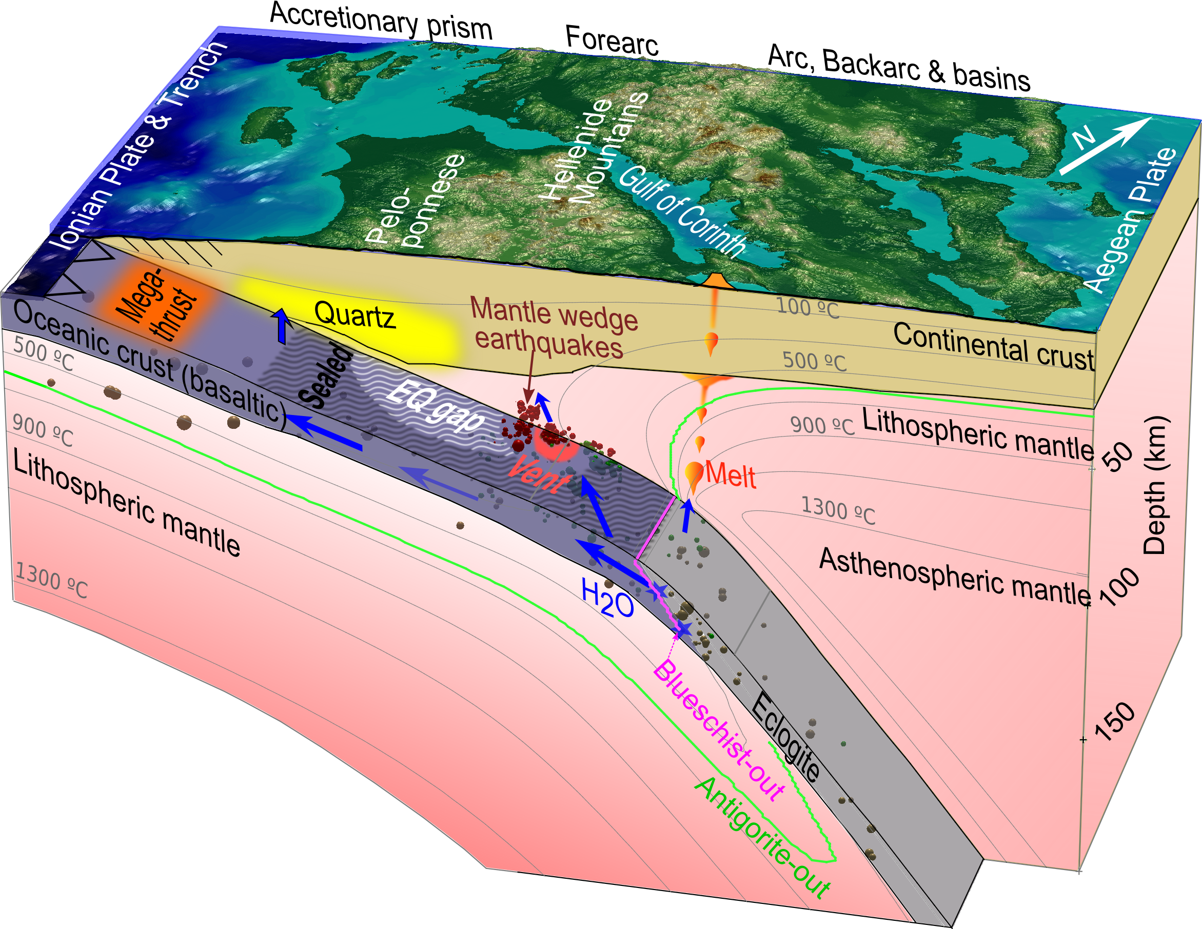
Felix Julian Halpaap1, Stephane Rondenay1, Alexander Perrin2, Saskia D B Goes3, Lars Ottemöller1, Florian Millet4, Håkon Austrheim5, Robert Shaw6 and Thomas Eeken7, (1)University of Bergen, Bergen, Norway, (2)Imperial College London, London, SW7, United Kingdom, (3)Imperial College London, Department of Earth Science and Engineering, London, SW7, United Kingdom, (4)LGLTPE Laboratoire de Géologie de Lyon : Terre, Planètes et Environnement, Villeurbanne Cedex, France, (5)University of Oslo, Oslo, Norway, (6)Imperial College London, London, United Kingdom, (7)Madison, WI, United States
Subducting plates release fluids as they plunge into Earth’s mantle and occasionally rupture to produce intraslab earthquakes. The relationship between these fluids and earthquakes has been debated. Here we combine new seismic observations and new thermal-petrologic models from the Western Hellenic subduction zone in Greece to investigate the relationship between fluids and earthquakes. From seismic images and relocated hypocenters of deep earthquakes (>35 km), we observe that earthquakes occur in three domains of the subduction zone: in the slab, on the plate interface, and in the mantle wedge. These observations are supported by a systematic difference in focal mechanisms and secondary arrival patterns (caused by the interactions of the local seismic waves with subduction discontinuities) between the domains. By comparing across other subduction zones where mantle wedge earthquakes occur (Greece, Lesser Antilles, E Honshu, New Zealand), we find that earthquakes in these cold slabs effectively track the flow of fluids from their source at >80 km depth to their sink at shallow (<40 km) depth. Between source and sink, the fluids flow updip under a sealed plate interface. In some locations, this seal breaks and fluids escape from the slab, through a vent on the interface, into a dry mantle wedge. Along their migration path, the fluids cause earthquakes in the slab, on the plate interface, and in the overlying mantle wedge, while the forearc slab updip of the vents consistently lacks earthquakes due to being fluid-starved. In eleven years (2006-2017) of detailed observations for Greece, the interface vents persistently hosted only small (Mw ≤ 3.7) earthquakes. Their combined release of seismic moment points to a small (55 km), suggesting that the vents are relevant for the nucleation of damaging earthquakes.